Understanding Tide Tables: A Beginner’s Guide
Whether you’re heading out for a day of fishing, coastal cruising, or just anchored at a sandbar, the tide will have an impact. Ignoring it can lead to more than just a ruined afternoon. It can lead to running aground or being unable to clear a bridge.
Find out how to read a tide table and be prepared for fluctuating water levels and currents on coastal U.S. waters.
Key Takeaways
- Understanding the tides is key to safe boating, especially for avoiding getting stuck on high ground or having issues navigating under bridges.
- Boaters need to understand and be prepared for high tides, low tides and currents to boat safely.
- Local Tide Tables are available for all U.S. coastal waters from the NOAA.
- You can read a Tide Table by looking at the information in the Time, Tide and Height columns, then cross-referencing that information with your own boating plans.
What Causes the Tides?
Tides are the rise and fall of sea levels caused by the gravitational pull of the moon and the sun, combined with the rotation of the Earth.
High Tide, Low Tide and Currents: How They Impact Boaters
You’ve probably heard of high and low tides, but may not know exactly how they come into play when boating.
High Tide (The Peak)
This is when the water is at its deepest, offering the most cushion over sandbars, rocks, and shallow inlets. While it’s the safest time to avoid running aground, it also reduces so-called “air draft”, meaning there is less clearance for your boat to pass under bridges.
Low Tide (The Trough)
At this stage, the water is at its shallowest, which can expose hidden hazards or leave you “high and dry” if you are anchored in a spot that was deep a few hours earlier.
The Transition (The Current)
As the water moves between these two states, it creates horizontal currents. An incoming (flood) tide pushes water toward the shore, while an outgoing (ebb) tide pulls it away, often creating strong flows in narrow channels that can significantly affect your boat’s speed and steering.
Semidiurnal, Diurnal and Mixed Tides
Most places in the U.S. experience two high tides and two low tides every lunar day (about 24 hours and 50 minutes). But tides don’t follow the same rhythm everywhere. Knowing your local pattern helps you avoid getting caught by a ‘low’ high tide.
- Semidiurnal: Two equal high and low tides daily (common on the Atlantic Coast).
- Diurnal: One high and one low tide daily (common in parts of the Gulf of Mexico).
- Mixed: Two unequal high and low tides daily (common on the Pacific Coast).
How to Read a Tide Table
A tide table from the NOAA shows three main types of information: Time, Tide and Height.
To use a tide table, you cross-reference the date of your trip with the times and heights listed to determine how much water you’ll have under your hull.
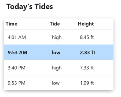
Source: NOAA
Step-by-Step Guide to Reading a Tide Table
Step 1: Check the date and location
Tides are hyper-local. You’ll need a Tide Table specifically for the harbor or inlet you are navigating, not just the general region.
Check NOAA Tides and Currents for the most accurate, station-specific data in U.S. waters.
Step 2: Identify high and low times
High and low times are indicated in separate columns.
If you notice a ‘missing’ high or low tide on your chart, don’t worry—it’s not a mistake! Because the tidal cycle lasts about 24 hours and 50 minutes (slightly longer than a standard day), the tide time occasionally ‘rolls over’ into the next calendar day. This is much like how the moon rises at a different time every night.
Most tables use a 24-hour (military) clock. For example, 14:30 is 2:30 PM.
Step 3: Read the height
The number next to the time (usually in feet) tells you how much the water level will rise above the “zero” depth shown on your GPS or paper chart.
In the U.S., tide heights are measured relative to MLLW (Mean Lower Low Water). If the table says the tide is -0.5 ft, it means the water is half a foot lower than the average low tide.
Example: If your boat has a 3-foot draft and the chart shows 2 feet of water at MLLW, you must wait for a tide height of at least +2 feet to pass safely.
Understanding “The Rule of Twelfths”
Remember, tides don’t rise at a constant speed. They start slowly, pick up speed in the middle, and slow down again as they reach high or low water. Boaters use the Rule of Twelfths to estimate how much the water level changes each hour, based on the high and low tide information included in a Tide Table:
- 1st Hour: 1/12 of the total range
- 2nd Hour: 2/12
- 3rd Hour: 3/12 (Fastest flow)
- 4th Hour: 3/12 (Fastest flow)
- 5th Hour: 2/12
- 6th Hour: 1/12
Tips for Navigating Safely at Low and High Tide
- There is a short period when the water is not moving horizontally, called ‘slack water’. This is usually the best time to navigate narrow channels or docks.
- Remember, you need to be aware of the tides to safely navigate under bridges. Check your mast or T-top height against the bridge’s clearance gauges, and verify that the “air draft” is adequate.
- You also need to remember the tides when navigating over bars. Check the “hull draft” to be sure there’s enough water over the bars at low tide.
- Plan for the current. Will you be fighting a 3-knot ebb tide on my way home?
- Anchoring your boat also involves staying aware of the tides, depending on your location: Did you let out enough line to account for the water rising another 5 feet?
- The vertical distance between high and low tide is called the range. Generally, the larger the tidal range, the stronger the current will be as the water rushes in or out.
Learn about safe boating practices with Drive A Boat USA
Drive A Boat USA offers 100% online, NASBLA-approved courses so you can get your American state-specific boating license quickly and easily from anywhere in the world. All content meets U.S. Boating Education Standards and is designed to make your next trip safe and enjoyable.
Sign up to get your boating license in California, New York or Florida today and learn everything you need to know to boat legally in the United States!
Tide Tables F.A.Q.
1. Why don’t tides always match predictions?
Tide tables are astronomical predictions—they calculate the effects of the moon and sun, but they cannot account for the weather. Wind and barometric pressure (especially low-pressure systems, which can lead to storm surges) impact the ocean surface.
2. Why do tide times shift daily?
Tide times shift because they follow a Lunar Day, not a 24-hour Solar Day. It takes the Earth 24 hours to rotate once, but because the moon is also moving in its orbit, it takes an extra 50 minutes for the same spot on Earth to “catch up” and align with the moon again. This is why high tide is roughly 50 minutes later each day.
3. How are tides predicted?
Scientists use Harmonic Analysis to predict the tides. By studying years of water-level data at a specific station, they identify “harmonic constituents”—mathematical patterns caused by the rotation of the Earth and the varying positions of the moon and sun. Computers combine these overlapping patterns into a single formula to predict future water levels.
4. Can I print a Tide Table?
Yes. While many boaters use digital apps, printing a hard copy from the NOAA is a smart safety backup. Many local bait shops and marinas still provide or sell printed annual tide booklets for their specific local waters.
5. Do lakes have tides?
The Great Lakes (and other large lakes in the U.S.) do experience true astronomical tides caused by the moon and sun, but they are so small that they are almost impossible to detect without scientific instruments.